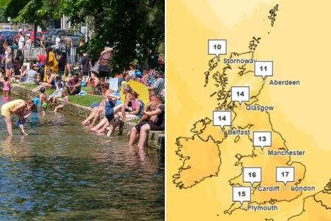
BRITS are set to bask in temperatures warmer than Ibiza this weekend before they hit a scorching 22C.
The weather is expected to see a sustained period of warmth as spring is finally ushered in after hail, thunder and snow.

Follow Flying Eze's live blog on the eclipse here.
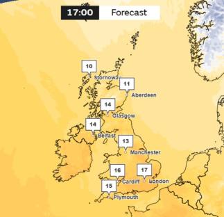
Tomorrow temperatures in parts of the UK will reach 17C, which is one degree more than expected in the Spanish holiday hot spot.
Met Office senior meteorologist Greg Dewhurst told Flying Eze: “There is still some uncertainty at the moment with the highest temperatures next week.
“Though as we head through next week, temperatures are likely to get into the high teens and then locally may get into the very low twenties of Celsius (20-22) across a few spots in northern and westerns parts of the UK by the middle of next week.”
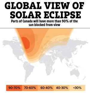
It comes as a partial solar eclipse will be visible in parts of the country on Saturday morning – ahead of the clocks going forward tomorrow.
After a bitter winter and some unseasonably subzero chilly spells this month, sunshine and warmth are returning.
Next week south-east England is expected to see the warmest temperatures, with parts of south-west Scotland, the West Midlands, and north-west England also experiencing the peak of the warmth later in the week.
The rise in temperatures follows a brief period of unsettled weather yesterday and today, which the Met Office described as occurring “in typical spring fashion”.
Despite the daytime warmth, clear skies at night could lead to chilly evenings and even rural frosts.
Met Office meteorologist Honor Criswick explained: “We are going to see a short-lived spell of unsettled weather this weekend before we transition back towards a blocked weather pattern as high pressure builds on Sunday and dominates our weather through much of next week.
“While daytime temperatures will be warm next week, nights will still be chilly and there is still a chance we could see some rural overnight frosts under the clear skies.”
The improving weather conditions in some parts of the UK could provide a promising backdrop for those hoping to catch a glimpse of the partial solar eclipse on Saturday morning.
The phenomenon occurs when the Moon passes between the Sun and the Earth, so that the Moon blocks the Sun's solar rays.
The three will not be completely aligned, meaning only part of the Sun will be covered.
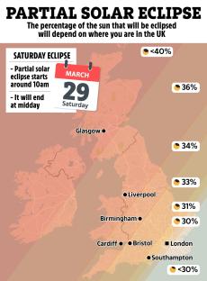
The eclipse is expected to be visible in the UK from 9.56am to 12.14pm on Saturday, with maximum coverage – where the greatest percentage of the Sun is covered – at 11.03am.
Some parts of the UK will see more of the eclipse than others. North-west Scotland is expected to see the most coverage with 47.9% in Gallan Head.
Dover in south-west England is set to see the least coverage of the eclipse with only 28.1% of the Sun blocked by the Moon, while Manchester is expected to have 36.1% of coverage.
Met Office meteorologist Alex Burkill said: “The further north west you are in the UK the more of an eclipse you are likely to have, whereas towards the south east it's a little bit less – but still 30%, and still a large chunk taken out of the Sun.”
Met Office cloud cover maps show clear skies across south-east England at the time that the eclipse starts, with partial cloud above Manchester and north-west England, and cloud above most of Scotland.
The areas expected to have some of the best eclipse coverage are also likely to see cloud and rain at the time.
Ms Criswick added: “The unfortunate thing is across the South East you're only going to see about 30% of that eclipse, whereas further north west you could see about 50%.
“But, unfortunately, that's where we're going to see the cloud and the rain, so there's very little chance of seeing it here.”
Five-day weather forecast
Today:
A dry but chilly start for many with the southeast holding onto the best of the sunshine. Turning cloudier and windier from the west with outbreaks of rain and drizzle sinking southeastwards, heavy at times for the northwest of Scotland.
Tonight:
Cloud and patchy rain in the northwest continues to sink southeastwards through the night. Turning drier behind with clear spells and blustery showers. Windy with the risk of coastal gales.
Sunday:
Any patchy rain and drizzle in the south soon clearing through the morning, with showers in the north also easing. Thereafter plenty of fine and dry weather albeit rather breezy.
Outlook for Monday to Wednesday:
Dry, bright and warm for most, with just a little rain in the north on Monday. Higher pressure becoming more dominant through the week to leave plenty of warm sunshine.